Tornado Confirmed Near Rossburn as Severe Weather Strikes Manitoba
Environment Canada investigates multiple storm reports; further tornado risk persists
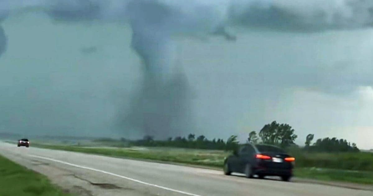
Environment Canada has confirmed that a tornado touched down near Rossburn, Manitoba, on Sunday evening as severe thunderstorms moved through western parts of the province. Meteorologist Shannon Moodie reported that the tornado was observed at approximately 7:59 p.m. local time, with initial confirmation based on several accounts received via social media and direct calls to the agency. The Northern Tornadoes Project has verified the occurrence.
Moodie indicated that a team would be dispatched on Monday to survey the affected area and assess the tornado's intensity, though the specific rating had yet to be determined as of Monday morning. She stated, "We can say for sure a tornado happened there. It does sound like there was damage, and they'll let us know what the rating is for that tornado." No information was available regarding the extent of the damage or any potential injuries at the time of reporting.
In addition to the confirmed tornado near Rossburn, Environment Canada also received unconfirmed reports of a possible tornado near Roblin. Moodie noted that while these reports are being taken seriously, confirmation is pending an on-site investigation.
The storm system produced additional severe weather across the region. Quarter-sized hail was reported near Shell Valley, and significant wind gusts were measured at Shoal Lake, reaching 85 km/h on Sunday evening and 89 km/h overnight. In Somerset, a wind gust of 100 km/h was recorded around 1 a.m. These conditions contributed to localized damage and heightened concern in affected communities.
The meteorological environment was regarded as conducive to tornado development. According to Moodie, the region experienced a persistent southerly flow that increased moisture levels and lowered cloud bases, combined with substantial wind shear. "With that moisture, you get cloud bases that are quite low to the ground. And then we had a lot of shear, which is really how the winds rotate through the atmosphere," she explained. The combination of these factors allowed for the formation of thunderstorms capable of producing tornadoes.
The system responsible for Sunday's tornadoes continued to pose a risk into Monday and beyond. Forecasters highlighted that the greatest risk for further severe weather would be between 4 p.m. and 9 p.m. Central Time on Monday, with the potential for storms to intensify and rotate during this period. Communities along and south of Highway 1 were identified as being in the highest risk area, with Winnipeg also at risk for severe weather later in the day as conditions evolved.
Forecasters indicated that large hail, damaging winds, and heavy rainfall remained possible, but the main concern was the development of additional tornadoes, particularly near the Ontario border in extreme southern Manitoba. The evolving nature of the storm system made it difficult to predict precise storm tracks and which communities might be most affected.
The threat from this system was not limited to Manitoba. As the weather pattern moved eastward, northwestern Ontario was forecast to experience severe weather into Monday night, with rotating storms expected between 6 p.m. and 10 p.m. Central Time. Areas south of Highway 11 and as far east as Highway 17 near Lake Superior were identified as being at risk.
Environment Canada and meteorological agencies continued to monitor the situation, with tornado watches and warnings issued for western Manitoba. Residents were advised to remain alert, particularly during periods of peak risk, and to follow safety protocols in the event of tornado warnings.
The forecast for southern Manitoba called for continued unsettled weather. Monday was expected to be mainly cloudy with a 30 per cent chance of showers and the risk of thunderstorms, accompanied by northeast winds at 20 km/h, gusting to 40 km/h, and a high of 24°C with a humidex of 30. Showers or thunderstorms were anticipated to end near midnight, after which southwest winds were projected to strengthen to 50 km/h, gusting to 70 km/h, with overnight temperatures dropping to a low of 14°C.
On Tuesday, sunny conditions were forecast for the morning, followed by increasing cloud and a 60 per cent chance of showers and the risk of another thunderstorm in the afternoon. Southwest winds were expected to persist at 50 km/h, gusting to 70 km/h, with a high of 24°C and a humidex of 29. Cloudy skies with a 60 per cent chance of showers were forecast for Wednesday, Canada Day, while improved, sunnier conditions were expected to return Thursday, with a projected high of 23°C.
The assessment and rating of the confirmed tornado near Rossburn, along with investigations into additional possible tornadoes, are ongoing. Authorities have emphasized the importance of storm preparedness and adherence to safety recommendations during periods of heightened severe weather risk. The events underscore the volatility of weather systems in the region and the challenges faced by meteorologists in forecasting and responding to rapidly changing storm dynamics.