Tornado and Severe Storms Bring Heavy Rain, Hail, and Flooding to Saskatchewan
Environment Canada confirms tornado near Pelly; nearly 100 mm of rain recorded in southern parts of the province
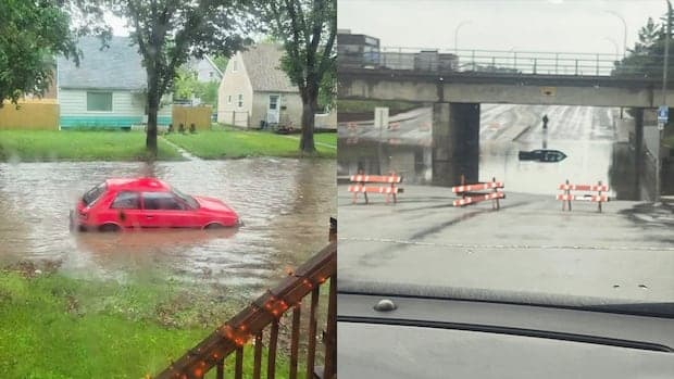
Severe weather systems impacted Saskatchewan over the weekend, bringing heavy rainfall, hail, flooding, and at least one confirmed tornado. Environment Canada tracked a series of slow-moving thunderstorms across the province's south and east-central regions, resulting in significant precipitation and localized damage.
In Regina, the storms delivered 52 millimetres of rain, with more than 50 millimetres falling within a single hour, which led to flooding in parts of the city. According to Kyle Ziolkowski, a meteorologist with Environment Canada, the system was characterized by its slow movement, which allowed large amounts of moisture to accumulate over specific areas. "It was just a slow-moving system that resulted in heavy rainfall. We're seeing a little bit more of that this year and that's just the way it kind of has worked out," Ziolkowski said. He noted that while thunderstorms are a regular occurrence in Saskatchewan during the summer, the intensity and duration of rainfall events can vary significantly.
The community of Mankota, located near Grasslands National Park, experienced some of the heaviest rainfall, recording 99.6 millimetres, with 75 millimetres falling in approximately one hour. In addition to the rain, Mankota saw wind gusts reaching 78 km/h. Pea-sized hail was reported near Big Beaver.
Environment Canada had issued warnings ahead of the storms, cautioning that slow-moving systems could result in very heavy rainfall, sometimes reaching 50 millimetres per hour in narrow bands. The storms that affected Regina and surrounding areas produced such bands, contributing to the rapid accumulation of water and subsequent flooding.
East-central Saskatchewan, particularly near the Manitoba border, also experienced significant storm activity. On Sunday, a tornado was confirmed to have touched down near Pelly, northeast of Yorkton, shortly after 6 p.m. Environment and Climate Change Canada (ECCC) received multiple reports of the tornado, both through direct storm reports and social media, and is working with the Northern Tornadoes Project, a research group based at Western University in London, Ontario, to assess the tornado's strength and the extent of any damage. Details regarding the tornado's category and a full assessment of damage are still pending.
Video footage shared on social media showed fallen trees in Pelly, including one that blocked a local road, as well as damaged roofs and scattered debris. ECCC stated, "Once a preliminary assessment has been completed, we will provide more information."
Another tornado was reported near Stornoway, south of Pelly, at approximately 2:17 p.m. on Sunday, but Environment Canada indicated that there is insufficient evidence at this time to confirm a tornado occurred in that instance. The agency is continuing its investigation in collaboration with the Northern Tornadoes Project.
Earlier in the day, Environment Canada had issued tornado warnings for east-central Saskatchewan, including communities in the rural municipalities of Clayton, Hudson Bay, Keys, Livingstone, Sliding Hills, Cote, and St. Phillips. The warnings were merged and tracked severe thunderstorms capable of producing tornadoes, damaging winds, large hail, and locally intense rainfall. The agency described the situation as "very dangerous and potentially life-threatening."
Reports during the event included a tornado 20 kilometres north of Wroxton and another five kilometres south of Pelly, both tracking northwards. The tornado warning for the region was lifted at 7:50 p.m. and replaced by a severe thunderstorm warning, which was subsequently lifted as the system moved out of the area.
The storms also produced large hail in several areas. Environment Canada documented hail measuring 24 millimetres in diameter, roughly the size of a quarter, near Burgis Beach on the eastern shore of Good Spirit Lake at about 4 p.m. Hail as large as 45 millimetres, similar in size to golf balls, was reported near North Portal, a community along the U.S. border, at 5 p.m.
The observed severe weather is part of a broader trend of elevated rainfall in Saskatchewan this year, according to meteorologists. The slow progression of some storm systems, combined with high moisture levels moving in from the central United States, has contributed to persistent and intense precipitation events. Ziolkowski explained that the lack of strong upper-level winds can cause these storms to linger, resulting in higher rainfall totals over affected areas.
The full extent of the impact from the tornado near Pelly and the broader storm system is still being assessed. Environment Canada and the Northern Tornadoes Project are conducting field investigations to determine the tornado's strength and to catalogue any structural and environmental damage.
Such events highlight the variable and sometimes volatile nature of summer weather patterns in Saskatchewan. While residents and authorities are accustomed to thunderstorms, the intensity of rainfall and occurrence of tornadoes and large hail present ongoing challenges for infrastructure, agriculture, and emergency response. As assessment continues, further details regarding property damage, agricultural effects, and any injuries, if present, are expected to be released by the relevant agencies.