B.C. Glacial Lake Faces Recurring Outburst Flood Risk as Warming Accelerates
Communities near Place Glacier continue evacuations amid climate-driven hazards and calls for enhanced monitoring
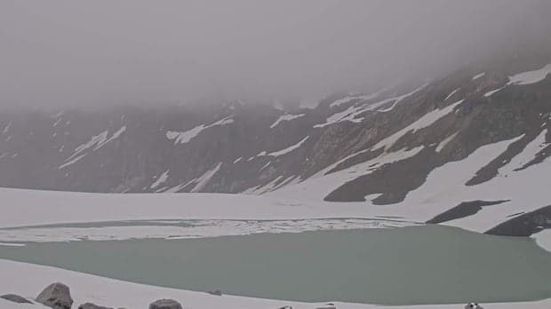
For the third consecutive year, communities near Place Glacier, approximately 180 kilometres northeast of Vancouver, have evacuated their homes in response to the imminent risk of a glacial lake outburst flood (GLOF). The situation has become a recurring concern for local residents, with water levels at the glacier's edge once again reaching thresholds that previously triggered destructive floods.
Place Glacier is among more than 15,000 glaciers in Western Canada experiencing accelerated retreat due to increasing temperatures and changing weather patterns, phenomena attributed by experts to fossil fuel emissions. According to Rodrigo Narro Pérez, assistant professor in the School of Earth, Environment and Society at McMaster University, the risk extends globally to an estimated 15 million people living downstream from glacial lakes, making the management of these hazards a matter of growing urgency.
Most glacial lakes are retained by moraines—natural dams composed of rock, sediment, and ice. GLOFs occur when these moraines are compromised, either by structural collapse or by rising water levels caused by rapid snowmelt, intense precipitation, or landslides. In the case of Place Glacier, the lake is classified as an ice-marginal lake, with the glacier itself functioning as the dam. Dan Shugar, who leads the waterSHED Lab at the University of Calgary, explains that this ice dam can reform year after year, as the glacier’s edge 'heals' itself, resulting in the lake repeatedly accumulating and draining.
Brian Menounos, geography professor at the University of Northern British Columbia, describes the current risk as the lake’s water now sits between the depths at which previous outbursts occurred in 2024 and 2025. The 2024 event discharged approximately 100,000 cubic metres of water and sediment, leading to flooding of properties along Gates Lake—one of two areas under ongoing evacuation orders. Menounos notes that GLOFs generally unfold over one to two days, with the process accelerating as water initially begins to drain beneath the ice wall where it meets the bedrock, further opening the channel and hastening the lake’s depletion.
Monitoring equipment installed at the site is designed to provide several hours of warning before an outburst occurs, allowing time for authorities to act. However, Menounos points out that Place Glacier is one of only two glaciers in British Columbia with federal monitoring, despite the thousands of glacial bodies across the province.
Efforts to protect communities from GLOFs have taken various forms in other regions, such as the Himalayas and Andes, where authorities have constructed concrete spillways or excavated channels to lower lake levels. These interventions are costly, often requiring millions of dollars annually. Shugar cautions that similar measures may be impractical at Place Glacier, as draining the basin would need to be repeated yearly for decades, and the glacier hosts multiple lakes.
Alternative proposals, such as using explosives to preemptively drain the lake, have been dismissed by British Columbia’s emergency management ministry, citing the lack of precedent and potential for unforeseen consequences. The ministry maintains that this is not a 'commonly used approach.'
Shugar emphasizes that robust monitoring remains the most effective tool for managing risk, enabling timely warnings to those in the projected path of a flood. Menounos adds that key data—such as the volume and temperature of the lake—can help predict the scale of a potential GLOF and should be communicated to provincial authorities, First Nations, and local residents.
Recent research by Menounos and colleagues has documented that glaciers in British Columbia and Alberta lost an estimated 30 gigatonnes of ice in 2025, marking the second-greatest loss on record for the region. Narro Pérez highlights that rising global temperatures, reduced snow accumulation, and increased rainfall are contributing to the formation and expansion of glacial lakes, thereby heightening risks to downstream communities.
As the landscape evolves, Shugar advocates for increased government funding to expand glacier monitoring, noting the necessity of reassessing hazards and risks every few years given the rapid environmental changes underway. He states, 'We need to be reevaluating the hazards and risks every couple of years, probably, in these mountain environments where the landscape is changing so much.'
Local authorities, including the Squamish-Lillooet Regional District, have ordered evacuations for two dozen properties in response to the current risk. Residents have described the repeated threat as 'unnerving,' as they await updates from monitoring teams and officials.
The ongoing situation at Place Glacier is situated within a wider global trend of increasing glacial lake formation and instability, attributed to anthropogenic climate change. While GLOFs have long been part of mountain hazard landscapes, their frequency and the number of communities at risk are both increasing. This underscores the importance of scientific monitoring, intergovernmental coordination, and proactive community engagement in mitigating future hazards.
The provincial and federal response continues to centre on real-time monitoring and emergency preparedness, as technical and financial constraints limit the feasibility of large-scale engineering interventions. The Place Glacier case is expected to inform future policy discussions on glacial hazard management in Canada and internationally.